Detailed description
To view the map area,
sign in or create account
sign in or create account
21.81 57.51, 28.25 59.63
Identity Description
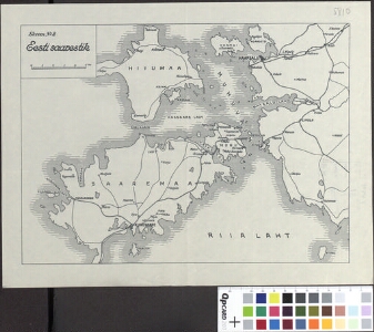
| Title | Eesti saarestik. Skeem nr. 2 |
|---|---|
| Map type | Single sheet map |
| Reference code | ERA.T-6.1.18 sheet 1 |
Cartographical and Publishing Description
| Main subject | military |
|---|---|
| Material designaton | plan |
| Manuscript/Printed | manuscript original |
| Created | 20. saj algus |
Components and Mathematical Description
| Components | graphical scale |
|---|---|
| Azimuth | Not set |
| Textual scale | 1 cm on 5 km |
| Relative scale | Not set |
Geographical Description
| Admin unit | Specification |
|---|---|
| Estonia (to 1917) | Saaremaa, Hiiumaa |
Physical Description
| Storage form | streched |
|---|---|
| Material and mounting | paper |
| Medium | ink |
| Dimensions (cm) | 33x26/A3 |
| Access-restrictions | No access restriction |