Detailed description
To view the map area,
sign in or create account
sign in or create account
23.85 57.87, 25.80 58.87
Identity Description
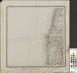
| Title | 0-16 Eesti-ja Liivimaa kubermangude kaart 1:84000, 0-16 Перновский и Вольмарский уезд |
|---|---|
| Map type | Single sheet map |
| Reference code | ERA.T-6.3.449 sheet 1 |
Cartographical and Publishing Description
| Main subject | administrative |
|---|---|
| Material designaton | map |
| Manuscript/Printed | printed |
| Published by | Sõjaväe topograafia osakond, IV 1916, Petrograd |
| Base map(s) year | 1905 |
| Created | 1915 |
Components and Mathematical Description
| Components | explication, grid lines, graphical scale |
|---|---|
| Azimuth | Not set |
| Relative scale | 840000 |
Geographical Description
| Admin unit | Specification |
|---|---|
| other / Europe Continent / Northern Europe Region / Latvia / Livonia Guberniya (to 1917) / Volmari County | |
| Estonia (to 1917) / Livonia Guberniya / Pärnu County |
Physical Description
| Storage form | streched |
|---|---|
| Material and mounting | paper |
| Medium | printed |
| Dimensions (cm) | 43x40/A2 |
| Access-restrictions | No access restriction |