Detailed description
To view the map area,
sign in or create account
sign in or create account
24.64628 58.39712, 24.66551 58.40917
Identity Description
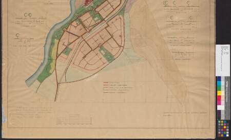
| Title | Sindi linna haljasalade ja sisetranspordi skeem |
|---|---|
| Map type | Single sheet map |
| Reference code | ERA.T-6.5.107 sheet 3 |
Notes
Topografo-geodeetilise plaani valmistanud insener-geodeet Aadu Kumari
Creators
| Firstname | Lastname | Occupation of cartographer | Creators position |
|---|---|---|---|
| Endel | Arman | insener | cartographer |
Cartographical and Publishing Description
| Main subject | town/borough |
|---|---|
| Material designaton | plan |
| Manuscript/Printed | manuscript original |
| Created | 1946 |
Components and Mathematical Description
| Components | legend for symbols, illustrated, compass, graphical scale |
|---|---|
| Azimuth | Not set |
| Textual scale | 1 sentimeetris 50 meetrit |
| Relative scale | 5000 |
Geographical Description
| Admin unit | Specification |
|---|---|
| Estonia (1917-1950) / Sindi City/Town (1938-1950) |
Physical Description
| Storage form | streched |
|---|---|
| Material and mounting | paper |
| Medium | ink+coloured |
| Dimensions (cm) | 96x100/2A0 |
| Access-restrictions | No access restriction |
Maps referring to this map
| Reference code | Manuscript/Printed |
|---|---|
| ERA.T-6.5.107 sheet 1 | manuscript original |