Detailed description
To view the map area,
sign in or create account
sign in or create account
23.77 58.66, 24.15 58.77
Identity Description
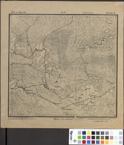
| Title | Eestimaa kubermang. 10-25 Lääne maakond. Эстляндская губерния. 10-25 Гапсальский уезд |
|---|---|
| Map type | Single sheet map |
| Reference code | ERA.T-6.3.760 sheet 1 |
Notes
Topograafiline
Cartographical and Publishing Description
| Main subject | administrative |
|---|---|
| Material designaton | map |
| Manuscript/Printed | printed |
| Published by | S. Topograafia osakonna trükk |
| Created | 1905 |
Components and Mathematical Description
| Components | grid lines, graphical scale |
|---|---|
| Azimuth | Not set |
| Relative scale | 42000 |
Geographical Description
| Admin unit | Specification |
|---|---|
| Estonia (to 1917) / Estonia Guberniya / Lääne County / Kirbla Parish |
Physical Description
| Storage form | streched |
|---|---|
| Material and mounting | paper |
| Medium | printed |
| Dimensions (cm) | 33x32/A2 |
| Access-restrictions | No access restriction |
Maps referred to by this map
| Reference code | Relation |
|---|---|
| ERA.T-6.3.760 sheet 2 | duplicate |
Maps referring to this map
| Reference code | Manuscript/Printed |
|---|---|
| ERA.T-6.3.172 sheet 203 | printed |