Detailed description
To view the map area,
sign in or create account
sign in or create account
21.79 57.52, 28.22 59.68
Identity Description
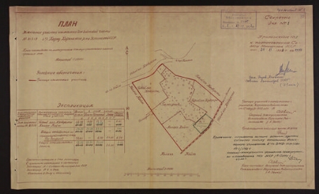
| Title | Harju rajooni Harku kn Haabersti abimajandi ja kolhoosi Koit maadest sõjaväele eraldatud maa-ala plaan |
|---|---|
| Map type | Single sheet map |
| Reference code | ERA.R-1.16.111 sheet 95 |
Cartographical and Publishing Description
| Main subject | military |
|---|---|
| Material designaton | plan |
| Manuscript/Printed | manuscript copy |
| Created | 1952 |
Components and Mathematical Description
| Components | Not set |
|---|---|
| Azimuth | Not set |
| Textual scale | 1:10000 |
| Relative scale | Not set |
Geographical Description
| Admin unit | Specification |
|---|---|
| Estonia (1950-1991) |
Physical Description
| Storage form | Not set |
|---|---|
| Material and mounting | paper |
| Medium | 0 |
| Dimensions (cm) | 27x44/A2 |
| Access-restrictions | No access restriction |