Detailed description
To view the map area,
sign in or create account
sign in or create account
24.70 59.09, 24.83 59.16
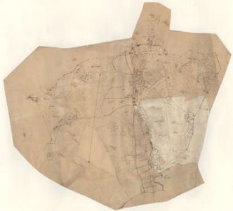
Identity Description
| Title | [Karta öfver Loall Hoff och des bönder] |
|---|---|
| Map type | Single sheet map |
| Reference code | EAA.1.2.C-IV-22 sheet 1 |
Notes
Punktidega mõisasüda, talud, möldri maja, leppemärgiga pealtvaates rehed; mõisa piir, piiripunktid; teedevõrk, maanteed, külateed, aiad; kõlvikute jaotus, omandijaotuse olemasolu; vetevõrk
Cartographical and Publishing Description
| Main subject | Not set |
|---|---|
| Material designaton | plan |
| Manuscript/Printed | manuscript rough draft |
| Created | 17. saj II pool |
Components and Mathematical Description
| Components | compass |
|---|---|
| Azimuth | 10 |
| Textual scale | [1:10400] |
| Relative scale | Not set |
Geographical Description
| Admin unit | Specification |
|---|---|
| Estonia (to 1917) / Estonia Guberniya / Harju County / Hageri Parish / Lohu Manor | Lohu, Seli; Loall, Selli |
Physical Description
| Storage form | rolled |
|---|---|
| Material and mounting | paper |
| Medium | ink+coloured |
| Dimensions (cm) | 81x70/A0 |
| Access-restrictions | No access restriction |