Detailed description
To view the map area,
sign in or create account
sign in or create account
26.96 57.85, 27.23 58.12
Identity Description
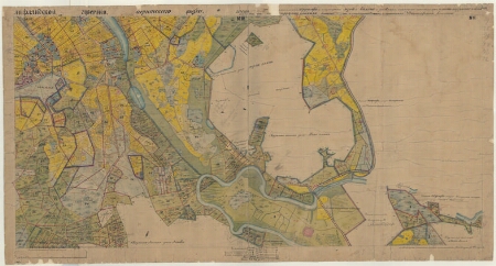
| Title | План крестьянских земель казеннаго имения Альть Киррумпе Койкюль, Лифляндской губерний Верроскаго уезда Альть Киррумпе Койкюльской волости |
|---|---|
| Map type | Single sheet map |
| Reference code | EAA.3724.4.1867 sheet 1 folio 10 |
Creators
| Firstname | Lastname | Occupation of cartographer | Creators position |
|---|---|---|---|
| A. | Telitsõn | noorem kroonumaamõõtja | cartographer |
Cartographical and Publishing Description
| Main subject | Not set |
|---|---|
| Material designaton | plan |
| Manuscript/Printed | manuscript duplicate |
| Created | 1876 |
Components and Mathematical Description
| Components | legend for symbols, graphical scale |
|---|---|
| Azimuth | Not set |
| Textual scale | [puudub] |
| Relative scale | 4200 |
Geographical Description
| Admin unit | Specification |
|---|---|
| Estonia (to 1917) / Livonia Guberniya / Võru County / Põlva Parish / Vana Koiola Manor | |
| Estonia (to 1917) / Livonia Guberniya / Võru County / Põlva Parish / Vastse Koiola Manor |
Physical Description
| Storage form | Not set |
|---|---|
| Material and mounting | paper |
| Medium | ink+coloured |
| Dimensions (cm) | 204x82/4A0 |
| Access-restrictions | No access restriction |