Detailed description
To view the map area,
sign in or create account
sign in or create account
24.59 58.98, 24.67 59.03
Identity Description
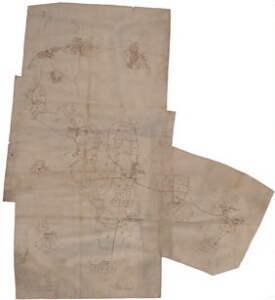
| Title | Allo med dess underliggand hem[ma]n i Rappel s[och]n och Harrien |
|---|---|
| Map type | Single sheet map |
| Reference code | EAA.1.2.C-IV-96 sheet 1 |
Notes
Talukohad kujutatud punktidega; mõisapiirid, piiripunktid; teedevõrk, aiad;
Cartographical and Publishing Description
| Main subject | Not set |
|---|---|
| Material designaton | plan |
| Manuscript/Printed | manuscript original |
| Created | 17. saj II pool (Estimated) |
Components and Mathematical Description
| Components | compass |
|---|---|
| Azimuth | Not set |
| Textual scale | [Svenska alnar; 1500 = 11,3cm] |
| Relative scale | 8250 |
Geographical Description
| Admin unit | Specification |
|---|---|
| Estonia (to 1917) / Estonia Guberniya / Harju County / Rapla Parish / Alu Manor | Sootaguse, Koigi, Mõisaaseme |
Physical Description
| Storage form | in binding |
|---|---|
| Material and mounting | paper |
| Medium | ink+pencil |
| Dimensions (cm) | 82x76/A0 |
| Access-restrictions | No access restriction |