Detailed description
To view the map area,
sign in or create account
sign in or create account
25.30 59.39, 25.69 59.64
Identity Description
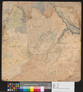
| Title | [Plan von den Gütern Kolk, Koenda, Neuenhof, Kahhal und Annia] |
|---|---|
| Map type | Subsheet |
| Reference code | EAA.3724.4.111 sheet 10 |
Belongs to main sheet
EAA.3724.4.111 sheet 1
Cartographical and Publishing Description
| Main subject | Not set |
|---|---|
| Material designaton | plan |
| Manuscript/Printed | manuscript rough draft |
| Created | 1880 (Estimated) |
Components and Mathematical Description
| Components | explication, compass |
|---|---|
| Azimuth | Not set |
| Textual scale | [1:4200] |
| Relative scale | Not set |
Geographical Description
| Admin unit | Specification |
|---|---|
| Estonia (to 1917) / Estonia Guberniya / Harju County / Kuusalu Parish / Kolga Manor |
Physical Description
| Storage form | streched |
|---|---|
| Material and mounting | paper+textile |
| Medium | ink+coloured |
| Dimensions (cm) | 54x54/A1 |
| Access-restrictions | No access restriction |