Detailed description
To view the map area,
sign in or create account
sign in or create account
24.96094 57.00425, 26.69678 58.02497
Identity Description
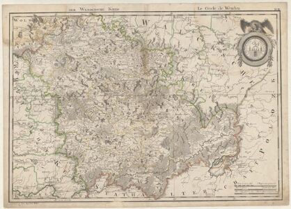
| Title | [Atlas von Liefland oder von den beyden Gouvernementen u. Herzogthümern Lief- und Ehstland und der Provintz Oesel. Das Ganze besteht aus einer Generallkarte und vierzehn Kreiskarten.] Der Wendensche Kreis |
|---|---|
| Map type | Subsheet |
| Reference code | EAA.1365.1.31 sheet 13 |
Belongs to main sheet
EAA.1365.1.31 sheet 6
Creators
| Firstname | Lastname | Occupation of cartographer | Creators position |
|---|---|---|---|
| Ludwig August krahv | Mellin | cartographer |
Cartographical and Publishing Description
| Main subject | Not set |
|---|---|
| Material designaton | map |
| Manuscript/Printed | printed |
| Created | 1798 |
Components and Mathematical Description
Geographical Description
| Admin unit | Specification |
|---|---|
| other / Europe Continent / Northern Europe Region / Latvia | |
| Estonia (to 1917) / Livonia Guberniya |
NB! location is approximate
Physical Description
| Storage form | folder |
|---|---|
| Material and mounting | paper |
| Medium | printed+coloured |
| Dimensions (cm) | 74x53/A1 |
| Access-restrictions | No access restriction |
Documents of description
| Reference code | Title | Creator | Year |
|---|---|---|---|
| EAA.1365.1.31 sheet 2, 5 | Observationa sur L´Atlas de Livonie et d´Esthonie | Mellin, Louis Auguste | 1798 |
Maps referred to by this map
| Reference code | Relation |
|---|---|
| EAA.854.4.470 sheet 4 | duplicate |
Maps referring to this map
| Reference code | Manuscript/Printed |
|---|---|
| EAA.854.4.470 sheet 4 | printed |
| EAA.2059.1.1464 sheet 10 | printed |
| EAA.2059.1.1464 sheet 2 | printed |
| EAA.2041.1.188 sheet 1 | printed |