Detailed description
To view the map area,
sign in or create account
sign in or create account
25.69153 58.29250, 25.93254 58.40812
Identity Description
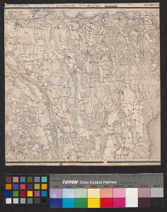
| Title | [Eesti topograafiline üheverstaline kaart] 14-34 Vana-Tänassilma |
|---|---|
| Map type | Subsheet |
| Reference code | EAA.2072.5.836 sheet 307 |
Belongs to main sheet
EAA.2072.5.836 sheet 1
Notes
Kokkuseadeleht asub samas karbis.
Cartographical and Publishing Description
| Main subject | Not set |
|---|---|
| Material designaton | map |
| Manuscript/Printed | printed |
| Published by | 1915 |
| Created | 1904 |
Components and Mathematical Description
| Components | Not set |
|---|---|
| Azimuth | Not set |
| Textual scale | 1:42000 |
| Relative scale | 42000 |
Geographical Description
| Admin unit | Specification |
|---|---|
| Estonia (to 1917) / Livonia Guberniya / Viljandi County | Tänassilma |
NB! location is approximate
Physical Description
| Storage form | in box |
|---|---|
| Material and mounting | paper |
| Medium | printed |
| Dimensions (cm) | 29x28/A3 |
| Access-restrictions | No access restriction |