Detailed description
To view the map area,
sign in or create account
sign in or create account
25.89 57.84, 26.07 57.95
Identity Description
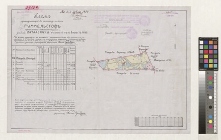
| Title | Планъ принадлежащей къ частному имению Гуммелсьгофъ - крестьянской повинностной земли - усадьбы Оятаре № 25А отделенный отъ ус. Валусте № 25 |
|---|---|
| Map type | Multiple-sheet map |
| Reference code | EAA.2469.1.10095 sheet 1 |
Subsheets
| Reference code |
|---|
| EAA.2469.1.10095 sheet 1p |
Creators
| Firstname | Lastname | Occupation of cartographer | Creators position |
|---|---|---|---|
| Otto | Grünberg | Liivimaa rüütelkonna vannutatud maamõõtja | cartographer |
| Ludwig | Jakobsenn | vannutatud maamõõtja | author of base map |
Cartographical and Publishing Description
| Main subject | farm map |
|---|---|
| Material designaton | plan |
| Manuscript/Printed | manuscript copy |
| Certified by | Liivimaa Maanõunike Kolleegiumi Katastriosakond, 03.11.1915 |
| Base map(s) year | 1912 |
| Created | 1915 |
Components and Mathematical Description
| Components | explication, compass, graphical scale |
|---|---|
| Azimuth | Not set |
| Textual scale | 1000 küünart = 11,7 cm |
| Relative scale | 5200 |
Geographical Description
| Admin unit | Specification |
|---|---|
| Estonia (to 1917) / Livonia Guberniya / Viljandi County / Helme Parish / Hummuli Manor | Ojatare nr 25A |
Physical Description
| Storage form | folder |
|---|---|
| Material and mounting | tracing cloth |
| Medium | ink+coloured |
| Dimensions (cm) | 42x60/A1 |
| Access-restrictions | No access restriction |