Detailed description
To view the map area,
sign in or create account
sign in or create account
25.89 57.84, 26.07 57.95
Identity Description
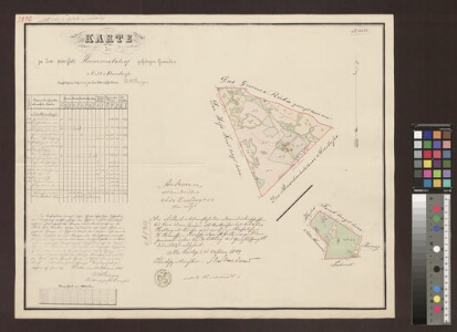
| Title | Karte des zu dem Privatgute Hummelshof gehörigen Gesindes Nr 54 Moistusse |
|---|---|
| Map type | Single sheet map |
| Reference code | EAA.2469.1.10095 sheet 3 |
Creators
| Firstname | Lastname | Occupation of cartographer | Creators position |
|---|---|---|---|
| Woldemar Carl | Breyer | Liivimaa rüütelkonna maamõõtja | cartographer |
Cartographical and Publishing Description
| Main subject | farm map |
|---|---|
| Material designaton | plan |
| Manuscript/Printed | manuscript original |
| Created | 1887 |
Components and Mathematical Description
| Components | explication, graphical scale |
|---|---|
| Azimuth | Not set |
| Textual scale | 1000 küünart = 11,7 cm |
| Relative scale | 5200 |
Geographical Description
| Admin unit | Specification |
|---|---|
| Estonia (to 1917) / Livonia Guberniya / Viljandi County / Helme Parish / Hummuli Manor | Mõistuse nr 54 |
Physical Description
| Storage form | folder |
|---|---|
| Material and mounting | paper |
| Medium | ink+coloured |
| Dimensions (cm) | 48x60/A1 |
| Access-restrictions | No access restriction |