Detailed description
To view the map area,
sign in or create account
sign in or create account
21.79 41.47347, 28.41 82.06518
Identity Description
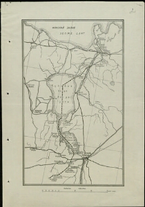
| Title | [Eesti ja Venemaa vahelise piiri kaart. Kuulub Eesti ja Venemaa vahel sõlmitud rahulepingu juurde] |
|---|---|
| Map type | Single sheet map |
| Reference code | ERA.1621.1.111 sheet 2 |
Cartographical and Publishing Description
| Main subject | border map |
|---|---|
| Material designaton | map |
| Manuscript/Printed | printed |
| Created | 1920 |
Components and Mathematical Description
| Components | grid lines |
|---|---|
| Azimuth | Not set |
| Textual scale | . |
| Relative scale | Not set |
Geographical Description
| Admin unit | Specification |
|---|---|
| other / Europe Continent / Eastern Europe Region / Russia | |
| Estonia (1917-1950) |
Physical Description
| Storage form | folder |
|---|---|
| Material and mounting | paper |
| Medium | printed |
| Dimensions (cm) | 32x22/A3 |
| Access-restrictions | No access restriction |