Detailed description
To view the map area,
sign in or create account
sign in or create account
24.46724 58.37380, 24.53625 58.39612
Identity Description
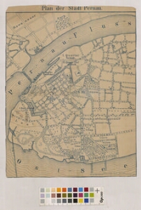
| Title | Plan der Stadt Pernau |
|---|---|
| Map type | Single sheet map |
| Reference code | LVVA.6828.4.555 sheet 1 |
Notes
hoonestus, majade numbrid
Cartographical and Publishing Description
| Main subject | town/borough |
|---|---|
| Material designaton | plan |
| Manuscript/Printed | printed |
| Created | 20. saj algus (Estimated) |
Components and Mathematical Description
| Components | graphical scale |
|---|---|
| Azimuth | Not set |
| Textual scale | 1 toll= 80 sülda |
| Relative scale | Not set |
Geographical Description
| Admin unit | Specification |
|---|---|
| Estonia (to 1917) / Livonia Guberniya / Pärnu County / Pärnu City/Town (1251-1917) |
Physical Description
| Storage form | Not set |
|---|---|
| Material and mounting | paper |
| Medium | printed |
| Dimensions (cm) | 36x28/A3 |
| Access-restrictions | Restrictions due to ownership |