Detailed description
To view the map area,
sign in or create account
sign in or create account
26.44 58.67, 26.72 58.94
Identity Description
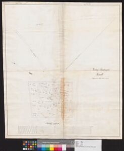
| Title | Kirchhof Situationsplan in Jensel |
|---|---|
| Map type | Single sheet map |
| Reference code | EAA.1388.1.1246 sheet 1 |
Cartographical and Publishing Description
| Main subject | Not set |
|---|---|
| Material designaton | plan |
| Manuscript/Printed | manuscript rough draft |
| Created | 1898 |
Components and Mathematical Description
| Components | compass, graphical scale |
|---|---|
| Azimuth | 340 |
| Textual scale | Maasstab von 400 Fuss engl. 1 Fuss = 1 Millimeter |
| Relative scale | 300 |
Geographical Description
| Admin unit | Specification |
|---|---|
| Estonia (to 1917) / Livonia Guberniya / Tartu County / Palamuse Parish / Kuremaa Manor |
Physical Description
| Storage form | streched |
|---|---|
| Material and mounting | paper |
| Medium | ink+pencil |
| Dimensions (cm) | 75x64/A0 |
| Access-restrictions | No access restriction |