Detailed description
To view the map area,
sign in or create account
sign in or create account
25.71 58.87, 28.25 59.58
Identity Description
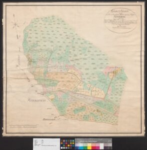
| Title | Geomet:Charte von dem Netheberg [План г. Нарвы и имения Неттеберг с принадлежащими ему деревнями] |
|---|---|
| Map type | Multiple-sheet map |
| Reference code | EAA.1646.1.2687 sheet 2 |
Creators
| Firstname | Lastname | Occupation of cartographer | Creators position |
|---|---|---|---|
| Otto Conrad | Schultz | Liivimaa rüütelkonna maamõõtja | land surveyor and cartographer |
Cartographical and Publishing Description
| Main subject | Not set |
|---|---|
| Material designaton | plan |
| Manuscript/Printed | manuscript original |
| Created | 1826 (Estimated) |
Components and Mathematical Description
| Components | legend for symbols, graphical scale |
|---|---|
| Azimuth | 351 |
| Relative scale | Not set |
Geographical Description
| Admin unit | Specification |
|---|---|
| Estonia (to 1917) / Estonia Guberniya / Viru County / Narva City/Town (to 1917) | |
| Estonia (to 1917) / Estonia Guberniya / Viru County | Neteberg |
Physical Description
| Storage form | streched |
|---|---|
| Material and mounting | paper |
| Medium | ink+coloured |
| Dimensions (cm) | 74x79/A1 |
| Access-restrictions | No access restriction |