Detailed description
To view the map area,
sign in or create account
sign in or create account
24.12407 59.31512, 29.04299 60.77886
Identity Description
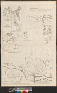
| Title | Частная карта Залива находящагося близъ Тольсбурга при реке Кунде./ A map of the Bay near Tolsbourgh on the river Kunda. |
|---|---|
| Map type | Multiple-sheet map |
| Reference code | EAA.1414.2.35 sheet 12 |
Belongs to main sheet
EAA.1414.2.35 sheet 1a
Subsheets
| Reference code |
|---|
| EAA.1414.2.35 sheet 13 |
| EAA.1414.2.35 sheet 14 |
Creators
| Firstname | Lastname | Occupation of cartographer | Creators position |
|---|---|---|---|
| Leonti | Spavarijev | kindralmajor | cartographer |
Cartographical and Publishing Description
| Main subject | hydrographic |
|---|---|
| Material designaton | map |
| Manuscript/Printed | printed |
| Published by | Mereväe trükikoda, 1823, St. Peterburg |
| Created | 1813 |
Components and Mathematical Description
| Components | illustrated, compass, graphical scale |
|---|---|
| Azimuth | Not set |
| Textual scale | erinevad mõõtkavad |
| Relative scale | Not set |
Geographical Description
| Admin unit | Specification |
|---|---|
| Estonia (to 1917) / Estonia Guberniya | Soome laht, Kunda jõgi |
| other / Europe Continent / Eastern Europe Region / Russia | Viiburi |
Physical Description
| Storage form | atlas |
|---|---|
| Material and mounting | paper |
| Medium | ink |
| Dimensions (cm) | 66x98/A0 |
| Access-restrictions | No access restriction |