Detailed description
To view the map area,
sign in or create account
sign in or create account
28.17478 59.35855, 28.20705 59.39163
Identity Description
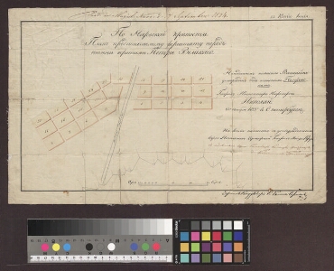
| Title | По Нарвскому крепости. Планъ предполагаемому форштату передъ новыми воротами Петра Великаго. |
|---|---|
| Map type | Single sheet map |
| Reference code | EAA.1646.1.2685 sheet 1 |
Creators
| Firstname | Lastname | Occupation of cartographer | Creators position |
|---|---|---|---|
| Tšeršents | 1-klassi konduktor | cartographer |
Cartographical and Publishing Description
| Main subject | town/borough |
|---|---|
| Material designaton | plan |
| Manuscript/Printed | manuscript copy |
| Created | 1823 |
Components and Mathematical Description
| Components | graphical scale |
|---|---|
| Azimuth | Not set |
| Textual scale | 210 sülda = 9,7cm |
| Relative scale | 4600 |
Geographical Description
| Admin unit | Specification |
|---|---|
| Estonia (to 1917) / Estonia Guberniya / Viru County / Narva City/Town (to 1917) | Narva kindlus |
Physical Description
| Storage form | streched |
|---|---|
| Material and mounting | paper+textile |
| Medium | ink+coloured |
| Dimensions (cm) | 27x45/A2 |
| Access-restrictions | No access restriction |