Detailed description
To view the map area,
sign in or create account
sign in or create account
24.83 59.33, 25.48 59.54
Identity Description
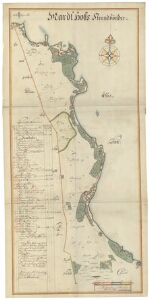
| Title | Mardt Hoff Strandbönder |
|---|---|
| Map type | Single sheet map |
| Reference code | EAA.1.2.C-III-14 sheet 1 |
Notes
Stiliseeritud leppemärkidega eristatud talukohad; teed, aiad, mõisapiirid ja piiripunktid; talukõlvikute omandijaotus; vetevõrk, rannajoon (Muuga laht), reljeef; illustreeritud kompass-roos, graafiline mõõtkava
Creators
| Firstname | Lastname | Occupation of cartographer | Creators position |
|---|---|---|---|
| Johan | Holmberg | maamõõtja | cartographer |
Cartographical and Publishing Description
| Main subject | Not set |
|---|---|
| Material designaton | plan |
| Manuscript/Printed | manuscript original |
| Created | 1693 |
Components and Mathematical Description
| Components | explication, illustrated, compass, graphical scale |
|---|---|
| Azimuth | Not set |
| Textual scale | Scala Ulnarum Svecicarum 2000 = 14,9 cm |
| Relative scale | 8250 |
Geographical Description
| Admin unit | Specification |
|---|---|
| Estonia (to 1917) / Estonia Guberniya / Harju County / Jõelähtme Parish / Maardu Manor | Randafer |
Physical Description
| Storage form | streched |
|---|---|
| Material and mounting | paper |
| Medium | ink+coloured |
| Dimensions (cm) | 118x57/A0 |
| Access-restrictions | No access restriction |