Detailed description
To view the map area,
sign in or create account
sign in or create account
26.44 57.63, 26.68 57.86
Identity Description
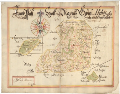
| Title | Jacob Pust Hoff uthi Rapins Gebiet och Urbs Kyrkspil belägit, Hörig under Gambla Antzen. |
|---|---|
| Map type | Multiple-sheet map |
| Reference code | EAA.308.2.188 sheet 1 |
Subsheets
| Reference code |
|---|
| EAA.308.2.188 sheet 1p |
Notes
Mõisasüda tähistatud maja-sümboliga. Küla piirid. Teedevõrk, palkteed. Mõisamaade külviväljad. Kaunistatud kompassroos. Verso: leppekirjad.
Creators
| Firstname | Lastname | Occupation of cartographer | Creators position |
|---|---|---|---|
| Erich | Reuter | cartographer |
Cartographical and Publishing Description
| Main subject | Not set |
|---|---|
| Material designaton | plan |
| Manuscript/Printed | manuscript original |
| Created | 1690 (Estimated) |
Components and Mathematical Description
| Components | explication, compass, graphical scale |
|---|---|
| Azimuth | Not set |
| Textual scale | 1800 küünart = 10,6 cm |
| Relative scale | 10400 |
Geographical Description
| Admin unit | Specification |
|---|---|
| Estonia (to 1917) / Livonia Guberniya / Võru County / Urvaste Parish / Vana Antsla Manor | Jacopust Hoff |
Physical Description
| Storage form | streched |
|---|---|
| Material and mounting | paper |
| Medium | ink+coloured |
| Dimensions (cm) | 44x58/A1 |
| Access-restrictions | No access restriction |