Detailed description
To view the map area,
sign in or create account
sign in or create account
24.63959 59.38984, 24.82361 59.46633
Identity Description
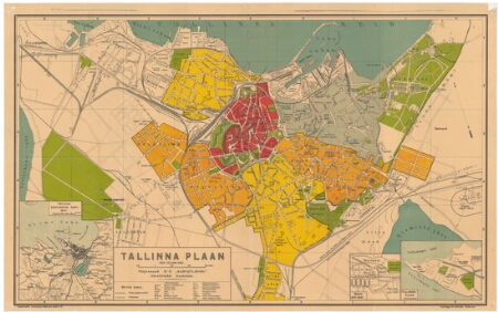
| Title | Tallinna plaan |
|---|---|
| Map type | Single sheet map |
| Reference code | EAA.2110.1.4820 sheet 4 |
Notes
Nurgas Tallinna ümbruskonna kaart, Nõmme alevi plaan, Telliskopli plaan
Cartographical and Publishing Description
| Main subject | town/borough |
|---|---|
| Material designaton | plan |
| Manuscript/Printed | printed |
| Published by | Lantzky ja Ko kivitrükk, 1922, Tallinn |
| Created | 1910 - 1920 (Estimated) |
Components and Mathematical Description
| Components | legend for symbols, compass, graphical scale |
|---|---|
| Azimuth | 340 |
| Textual scale | Mõõt 125 sülda tollis |
| Relative scale | 10500 |
Geographical Description
| Admin unit | Specification |
|---|---|
| Estonia (1917-1950) / Tallinn City/Town (1917-1950) | Tallinn |
Physical Description
| Storage form | folder |
|---|---|
| Material and mounting | paper |
| Medium | printed+coloured |
| Dimensions (cm) | 46x73/A1 |
| Access-restrictions | No access restriction |