Detailed description
To view the map area,
sign in or create account
sign in or create account
24.78 59, 24.81 59.01
Identity Description
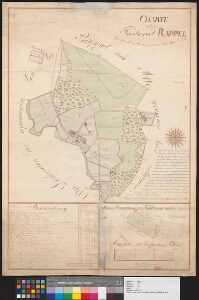
| Title | Charte von dem Pastorat Rappel |
|---|---|
| Map type | Single sheet map |
| Reference code | EAA.3724.4.274 sheet 2 |
Creators
| Firstname | Lastname | Occupation of cartographer | Creators position |
|---|---|---|---|
| Johann | Hildebrandt | vannutatud maamõõtja | cartographer |
Cartographical and Publishing Description
| Main subject | Not set |
|---|---|
| Material designaton | plan |
| Manuscript/Printed | manuscript original |
| Created | 1843 |
Components and Mathematical Description
| Components | explication, compass |
|---|---|
| Azimuth | Not set |
| Textual scale | 300 sülda |
| Relative scale | Not set |
Geographical Description
| Admin unit | Specification |
|---|---|
| Estonia (to 1917) / Estonia Guberniya / Harju County / Rapla Parish / Rapla Church manor |
Physical Description
| Storage form | Not set |
|---|---|
| Material and mounting | paper |
| Medium | ink+coloured |
| Dimensions (cm) | 72x51/A1 |
| Access-restrictions | No access restriction |