Detailed description
To view the map area,
sign in or create account
sign in or create account
23.60 58.73, 25.86 59.69
Identity Description
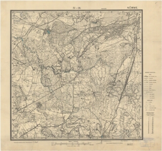
| Title | Eesti topograafiline kaart 1:25000, Nõmme IV-28 |
|---|---|
| Map type | Single sheet map |
| Reference code | ERA.T-6.3.111 sheet 1 |
Creators
| Firstname | Lastname | Occupation of cartographer | Creators position |
|---|---|---|---|
| E. | Bach | sõjaväe topograafiajaoskonna ülem | cartographer |
Cartographical and Publishing Description
| Main subject | administrative |
|---|---|
| Material designaton | map |
| Manuscript/Printed | printed |
| Published by | Riigi trükikoda, VII 1925 |
| Created | 1925 |
Components and Mathematical Description
| Components | explication, legend for symbols, grid lines, graphical scale |
|---|---|
| Azimuth | Not set |
| Relative scale | 25000 |
Geographical Description
| Admin unit | Specification |
|---|---|
| Estonia (1917-1950) / Harju County | Nõmme linn |
Physical Description
| Storage form | streched |
|---|---|
| Material and mounting | paper |
| Medium | printed |
| Dimensions (cm) | 55x60/A1 |
| Access-restrictions | No access restriction |