Detailed description
To view the map area,
sign in or create account
sign in or create account
24.56 58.88, 24.68 58.94
Identity Description
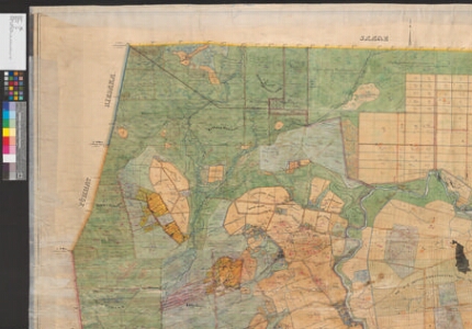
| Title | Das privat Gut Kappel im Ehstländischen Gouvernement, Südharrienschen Kreise und Rappelschen Kirchspiele |
|---|---|
| Map type | Single sheet map |
| Reference code | EAA.1373.1.16 sheet 1 |
Creators
| Firstname | Lastname | Occupation of cartographer | Creators position |
|---|---|---|---|
| J. | Eichenfeldt | vannutatud maamõõtja | cartographer |
Cartographical and Publishing Description
| Main subject | Not set |
|---|---|
| Material designaton | plan |
| Manuscript/Printed | manuscript original |
| Created | 1850 |
Components and Mathematical Description
| Components | compass, graphical scale |
|---|---|
| Azimuth | Not set |
| Textual scale | Maasstab von 300 Faden russisch = 6 englisch Zolle |
| Relative scale | 4200 |
Geographical Description
| Admin unit | Specification |
|---|---|
| Estonia (to 1917) / Estonia Guberniya / Harju County / Rapla Parish / Kabala Manor | mõisasüda, Kabala jõgi |
Physical Description
| Storage form | rolled |
|---|---|
| Material and mounting | paper+textile |
| Medium | ink+coloured |
| Dimensions (cm) | 172x151/4A0 |
| Access-restrictions | No access restriction |