Detailed description
To view the map area,
sign in or create account
sign in or create account
26.76 57.70, 26.95 57.80
Identity Description
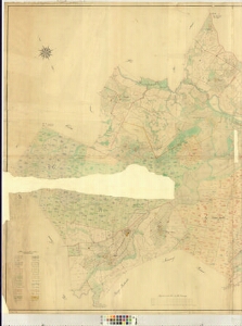
| Title | Special-Charte von dem im Livl. Gouvernement, Werroschen Kreisen und Raugeschen Kirchspiele belegenen priv. Gute Rauge Folio I |
|---|---|
| Map type | Single sheet map |
| Reference code | LVVA.6828.4.439 sheet 1 |
Creators
| Firstname | Lastname | Occupation of cartographer | Creators position |
|---|---|---|---|
| Paul Alexander | Stern | land surveyor and cartographer |
Cartographical and Publishing Description
| Main subject | Not set |
|---|---|
| Material designaton | plan |
| Manuscript/Printed | manuscript original |
| Created | 1873 |
Components and Mathematical Description
| Components | explication, legend for symbols, illustrated, compass, graphical scale |
|---|---|
| Azimuth | Not set |
| Textual scale | 1300 Ellen[=15,3cm] |
| Relative scale | Not set |
Geographical Description
| Admin unit | Specification |
|---|---|
| Estonia (to 1917) / Livonia Guberniya / Võru County / Rõuge Parish / Rõuge Manor | Antimikko, Tiedo, Matsi, Jaanibebo, Rautseppa, Suureruga, Weikeruga külad |
Physical Description
| Storage form | Not set |
|---|---|
| Material and mounting | paper |
| Medium | ink+coloured |
| Dimensions (cm) | 110x60/A0 |
| Access-restrictions | Restrictions due to ownership |