Detailed description
To view the map area,
sign in or create account
sign in or create account
24.83 59.33, 25.48 59.54
Identity Description
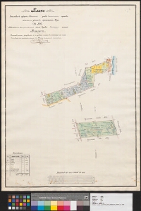
| Title | План Эстляндской губерни, Ревельскаго уезда, Егелехтскаго прихода, земельных участков крестьянскаго двора Оя № 95 выделенных из крестьянской земли деревни Рандфер имения Маарт.. |
|---|---|
| Map type | Single sheet map |
| Reference code | EAA.3724.4.166 sheet 1 |
Creators
| Firstname | Lastname | Occupation of cartographer | Creators position |
|---|---|---|---|
| Louis Heinrich Osvald | Buschmann | cartographer |
Cartographical and Publishing Description
| Main subject | Not set |
|---|---|
| Material designaton | plan |
| Manuscript/Printed | manuscript duplicate |
| Base map(s) year | 1893 |
| Created | 1912 |
Components and Mathematical Description
| Components | explication, compass |
|---|---|
| Azimuth | Not set |
| Textual scale | 1 toll=50 sülda |
| Relative scale | 4200 |
Geographical Description
| Admin unit | Specification |
|---|---|
| Estonia (to 1917) / Estonia Guberniya / Harju County / Jõelähtme Parish / Maardu Manor | Oja nr 95 |
Physical Description
| Storage form | Not set |
|---|---|
| Material and mounting | paper |
| Medium | ink+coloured |
| Dimensions (cm) | 67x48/A1 |
| Access-restrictions | No access restriction |