Detailed description
To view the map area,
sign in or create account
sign in or create account
12.09 41.24, 40.17 59.66
Identity Description
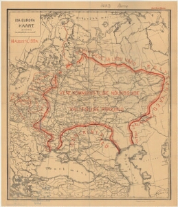
| Title | Ida-Euroopa kaart 14 augustil 1919 aastal |
|---|---|
| Map type | Single sheet map |
| Reference code | ERA.T-6.1.68 sheet 1 |
Cartographical and Publishing Description
| Main subject | military |
|---|---|
| Material designaton | map |
| Manuscript/Printed | printed |
| Published by | S. Topograafia osakonna väljaanne ja kivitrükk, 1919 |
| Created | 1919 |
Components and Mathematical Description
| Components | graphical scale |
|---|---|
| Azimuth | Not set |
| Textual scale | 1 tollis 175 versta |
| Relative scale | Not set |
Geographical Description
| Admin unit | Specification |
|---|---|
| other / Europe Continent / Eastern Europe Region |
Physical Description
| Storage form | streched |
|---|---|
| Material and mounting | paper |
| Medium | printed+coloured |
| Dimensions (cm) | 54x47/A1 |
| Access-restrictions | No access restriction |
Maps referred to by this map
| Reference code | Relation |
|---|---|
| ERA.T-6.1.68 sheet 2 | duplicate |
| ERA.T-6.1.68 sheet 3 | duplicate |
| ERA.T-6.1.68 sheet 4 | duplicate |
| ERA.T-6.1.68 sheet 5 | duplicate |