Detailed description
To view the map area,
sign in or create account
sign in or create account
21.80 57.76, 23.44 58.68
Identity Description
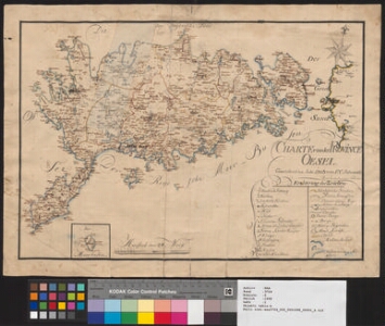
| Title | Charte von der Province Oesel |
|---|---|
| Map type | Single sheet map |
| Reference code | EAA.3724.5.1998 sheet 1 |
Creators
| Firstname | Lastname | Occupation of cartographer | Creators position |
|---|---|---|---|
| Friedrich Christoph | Sehrwald | Saaremaa kreisimaamõõtja | cartographer |
Cartographical and Publishing Description
| Main subject | Not set |
|---|---|
| Material designaton | plan |
| Manuscript/Printed | manuscript original |
| Created | 1803 |
Components and Mathematical Description
| Components | legend for symbols, compass |
|---|---|
| Azimuth | Not set |
| Relative scale | 25100 |
Geographical Description
| Admin unit | Specification |
|---|---|
| Estonia (to 1917) / Livonia Guberniya / Saare County |
Physical Description
| Storage form | Not set |
|---|---|
| Material and mounting | paper |
| Medium | ink+coloured |
| Dimensions (cm) | 51x37/A2 |
| Access-restrictions | No access restriction |