Detailed description
To view the map area,
sign in or create account
sign in or create account
21.79 57.51, 28.41 59.69
Identity Description
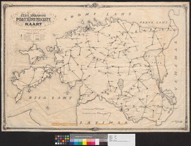
| Title | Eesti vabariigi postiühenduste kaart |
|---|---|
| Map type | Single sheet map |
| Reference code | ERA.T-6.3.1189 sheet 1 |
Notes
Postipeavalitsuse väljaanne
Cartographical and Publishing Description
| Main subject | communication |
|---|---|
| Material designaton | map |
| Manuscript/Printed | printed |
| Published by | S. Kartografia Trükk, 1923 |
| Created | 1923 |
Components and Mathematical Description
| Components | explication, legend for symbols, graphical scale |
|---|---|
| Azimuth | Not set |
| Relative scale | Not set |
Geographical Description
| Admin unit | Specification |
|---|---|
| Estonia (1917-1950) |
Physical Description
| Storage form | streched |
|---|---|
| Material and mounting | paper+textile |
| Medium | printed |
| Dimensions (cm) | 70x100/A0 |
| Access-restrictions | No access restriction |
Maps referred to by this map
| Reference code | Relation |
|---|---|
| ERA.T-6.3.1189 sheet 2 | duplicate |
| ERA.T-6.3.1189 sheet 3 | duplicate |