Detailed description
To view the map area,
sign in or create account
sign in or create account
24.46724 58.37380, 24.53625 58.39612
Identity Description
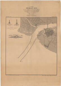
| Title | Pärnu sadama plaan. План Перновского порта |
|---|---|
| Map type | Single sheet map |
| Reference code | ERA.T-6.3.1397 sheet 1 |
Cartographical and Publishing Description
| Main subject | hydrographic |
|---|---|
| Material designaton | plan |
| Manuscript/Printed | printed |
| Base map(s) year | 1871-1898 |
| Created | 1900 |
Components and Mathematical Description
| Components | graphical scale |
|---|---|
| Azimuth | Not set |
| Textual scale | 1 toll = 100 sülda |
| Relative scale | Not set |
Geographical Description
| Admin unit | Specification |
|---|---|
| Estonia (to 1917) / Livonia Guberniya / Pärnu County / Pärnu City/Town (1251-1917) |
Physical Description
| Storage form | streched |
|---|---|
| Material and mounting | paper |
| Medium | printed |
| Dimensions (cm) | 72x50/A1 |
| Access-restrictions | No access restriction |