Detailed description
To view the map area,
sign in or create account
sign in or create account
20.96 41.47347, 28.41 82.06518
Identity Description
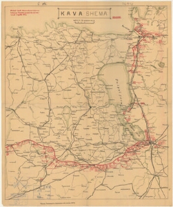
| Title | Kindral-staabi maakuulamise osakonna teadaanne vaenlase jõudude üle meie väerinnal 11. aprillil 1919. a. |
|---|---|
| Map type | Single sheet map |
| Reference code | ERA.T-6.1.75 sheet 1 |
Cartographical and Publishing Description
| Main subject | military |
|---|---|
| Material designaton | map |
| Manuscript/Printed | printed |
| Published by | Sõjaväe Topograafia jaoskonna väljaanne nr. 16, 1919 |
| Created | 1919 |
Components and Mathematical Description
| Components | graphical scale |
|---|---|
| Azimuth | Not set |
| Textual scale | 15 versta tollis |
| Relative scale | Not set |
Geographical Description
| Admin unit | Specification |
|---|---|
| Estonia (1917-1950) | |
| other / Europe Continent / Eastern Europe Region / Russia | |
| other / Europe Continent / Northern Europe Region / Latvia |
Physical Description
| Storage form | streched |
|---|---|
| Material and mounting | paper |
| Medium | printed+coloured |
| Dimensions (cm) | 55x45/A1 |
| Access-restrictions | No access restriction |