Detailed description
To view the map area,
sign in or create account
sign in or create account
26.32324 57.38460, 26.96045 57.87748
Identity Description
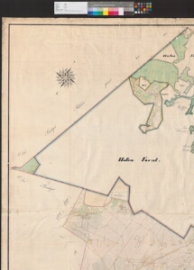
| Title | General-Charte von dem im Livlaendischen Gouvernement, Wenden-Walkschen Kreise und Luhdeschen Kirchspiele belegenen Privatgute Luhde-Grosshof |
|---|---|
| Map type | Single sheet map |
| Reference code | EAA.3724.4.1374 sheet 1 |
Creators
| Firstname | Lastname | Occupation of cartographer | Creators position |
|---|---|---|---|
| H. | Pusereffsky | kroonumaamõõtja | cartographer |
Cartographical and Publishing Description
| Main subject | Not set |
|---|---|
| Material designaton | plan |
| Manuscript/Printed | manuscript original |
| Certified by | Tartu kreisikohus, 27.02.1874 |
| Created | 1867 |
Components and Mathematical Description
| Components | compass, graphical scale |
|---|---|
| Azimuth | 25 |
| Textual scale | Maasstab von 1300 livl. Ellen gleich 1/4 Elle Feldmaass = 15,1 cm |
| Relative scale | 5200 |
Geographical Description
| Admin unit | Specification |
|---|---|
| Estonia (to 1917) / Livonia Guberniya / Valga County / Lugazi Parish / Paju Manor | |
| other / Europe Continent / Northern Europe Region / Latvia |
Physical Description
| Storage form | rolled |
|---|---|
| Material and mounting | paper+textile |
| Medium | ink+coloured |
| Dimensions (cm) | 169x158/4A0 |
| Access-restrictions | No access restriction |