Detailed description
To view the map area,
sign in or create account
sign in or create account
20.96 55.67, 28.25 59.63
Identity Description
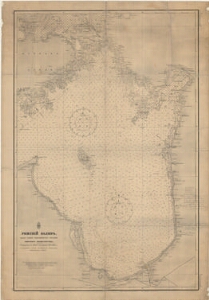
| Title | Riia laht. Рижский залив |
|---|---|
| Map type | Single sheet map |
| Reference code | ERA.T-6.3.1302 sheet 1 |
Cartographical and Publishing Description
| Main subject | hydrographic |
|---|---|
| Material designaton | map |
| Manuscript/Printed | printed |
| Created | 1862 |
Components and Mathematical Description
| Components | legend for symbols, grid lines, compass, graphical scale |
|---|---|
| Azimuth | Not set |
| Textual scale | 3 miili = 1 toll |
| Relative scale | Not set |
Geographical Description
| Admin unit | Specification |
|---|---|
| Estonia (to 1917) | |
| other / Europe Continent / Northern Europe Region / Latvia |
Physical Description
| Storage form | streched |
|---|---|
| Material and mounting | paper |
| Medium | printed |
| Dimensions (cm) | 100x70/A0 |
| Access-restrictions | No access restriction |