Detailed description
To view the map area,
sign in or create account
sign in or create account
26.01 57.51, 27.63 58.39
Identity Description
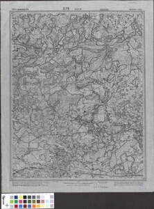
| Title | Liivimaa kubermang. Võru maakond, Л.72 XLIX-10 Верроский уезд |
|---|---|
| Map type | Single sheet map |
| Reference code | ERA.T-6.3.535 sheet 1 |
Notes
Salajane
Cartographical and Publishing Description
| Main subject | administrative |
|---|---|
| Material designaton | map |
| Manuscript/Printed | printed |
| Published by | 1929 |
| Created | 1912 - 1913 |
Components and Mathematical Description
| Components | grid lines, graphical scale |
|---|---|
| Azimuth | Not set |
| Relative scale | 42000 |
Geographical Description
| Admin unit | Specification |
|---|---|
| Estonia (to 1917) / Livonia Guberniya / Võru County |
Physical Description
| Storage form | streched |
|---|---|
| Material and mounting | paper |
| Medium | printed |
| Dimensions (cm) | 54x41/A2 |
| Access-restrictions | No access restriction |
Maps referred to by this map
| Reference code | Relation |
|---|---|
| ERA.T-6.3.535 sheet 2 | |
| ERA.T-6.3.535 sheet 3 | duplicate |
| ERA.T-6.3.535 sheet 4 | duplicate |