Detailed description
To view the map area,
sign in or create account
sign in or create account
28.02 59.29, 28.40 59.56
Identity Description
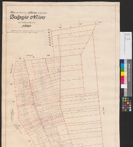
| Title | Viru maakonnas Narva vallas oleva Dolgaja Niiva korralduspiirkonna plaan |
|---|---|
| Map type | Single sheet map |
| Reference code | ERA.T-3.24.1661 sheet 1 |
Creators
| Firstname | Lastname | Occupation of cartographer | Creators position |
|---|---|---|---|
| August | Toom | vannutatud maamõõtja | land surveyor |
Cartographical and Publishing Description
| Main subject | other |
|---|---|
| Material designaton | plan |
| Manuscript/Printed | manuscript original |
| Created | 1931 - 1939 |
Components and Mathematical Description
| Components | compass |
|---|---|
| Azimuth | Not set |
| Textual scale | 1 sentimeetris 40 meetrit |
| Relative scale | 4000 |
Geographical Description
| Admin unit | Specification |
|---|---|
| Estonia (1917-1950) / Viru County / Narva Commune (1938-1945) |
Physical Description
| Storage form | rolled |
|---|---|
| Material and mounting | paper+textile |
| Medium | ink+pencil |
| Dimensions (cm) | 146x65/2A0 |
| Access-restrictions | No access restriction |