Detailed description
To view the map area,
sign in or create account
sign in or create account
27.48 58.99, 27.89 59.22
Identity Description
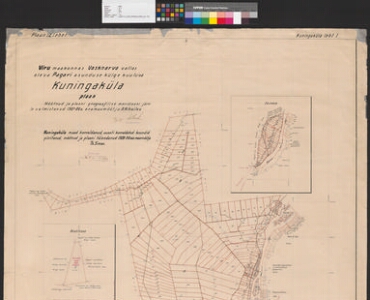
| Title | Viru maakonnas, Vasknarva vallas oleva Pagari asunduse külge kuuluva Kuningaküla plaan. Plaan kaheteistkümnel lehel, leht nr. 1 |
|---|---|
| Map type | Single sheet map |
| Reference code | ERA.T-3.22.246 sheet 1 |
Creators
| Firstname | Lastname | Occupation of cartographer | Creators position |
|---|---|---|---|
| A. | Mihailov | author of base map | |
| T. | Simon | land surveyor |
Cartographical and Publishing Description
| Main subject | farm map |
|---|---|
| Material designaton | plan |
| Manuscript/Printed | manuscript original |
| Certified by | Katastri Amet, 23. mai 1930 |
| Base map(s) year | 1927-1928 |
| Created | 1930 |
Components and Mathematical Description
| Components | explication |
|---|---|
| Azimuth | Not set |
| Relative scale | 10000 |
Geographical Description
| Admin unit | Specification |
|---|---|
| Estonia (1917-1950) / Viru County / Vasknarva Commune (1917-1950) |
Physical Description
| Storage form | rolled |
|---|---|
| Material and mounting | paper+textile |
| Medium | ink+coloured |
| Dimensions (cm) | 147x102/2A0 |
| Access-restrictions | No access restriction |
Maps referred to by this map