Detailed description
To view the map area,
sign in or create account
sign in or create account
24.45 58.62, 24.58 58.75
Identity Description
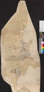
| Title | [Karte des Gutes Kailes] |
|---|---|
| Map type | Single sheet map |
| Reference code | EAA.2072.5.772 sheet 1 |
Cartographical and Publishing Description
| Main subject | Not set |
|---|---|
| Material designaton | plan |
| Manuscript/Printed | manuscript original |
| Created | 1805 |
Components and Mathematical Description
| Components | compass, graphical scale |
|---|---|
| Azimuth | Not set |
| Textual scale | 2000 küünart= 11,7 cm |
| Relative scale | 10400 |
Geographical Description
| Admin unit | Specification |
|---|---|
| Estonia (to 1917) / Livonia Guberniya / Pärnu County / Pärnu Jaagupi Parish / Kaelase Manor |
Physical Description
| Storage form | rolled |
|---|---|
| Material and mounting | paper |
| Medium | ink+coloured |
| Dimensions (cm) | 142x51/2A0 |
| Access-restrictions | No access restriction |