Detailed description
To view the map area,
sign in or create account
sign in or create account
26.74 58.37, 26.79 58.39
Identity Description
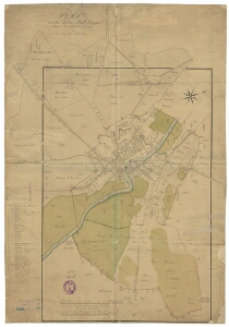
| Title | Plan von der Kreis Stadt Dorpat dessen Jurisdictions-Grenze und umher liegende Situation. |
|---|---|
| Map type | Single sheet map |
| Reference code | EAA.2623.1.2049 sheet 33 |
Creators
| Firstname | Lastname | Occupation of cartographer | Creators position |
|---|---|---|---|
| Joh. Heinr. | Galmeister | Liivimaa kubermangu maamõõtja | cartographer |
| Carl Joh. | Zeibel | author of base map |
Cartographical and Publishing Description
| Main subject | Not set |
|---|---|
| Material designaton | plan |
| Manuscript/Printed | manuscript copy |
| Base map(s) year | 1798 |
| Created | 1837 |
Components and Mathematical Description
| Components | explication, compass, graphical scale |
|---|---|
| Azimuth | 70 |
| Textual scale | 500 Faden russisch oder eien Russische Werst a 1750 Schwedische Ellen = 10 cm |
| Relative scale | 10650 |
Geographical Description
| Admin unit | Specification |
|---|---|
| Estonia (to 1917) / Livonia Guberniya / Tartu County / Tartu Maarja Parish / Jaama Manor | Tartu Kesklinn, Ülejõe, Jaamamõisa |
Physical Description
| Storage form | streched |
|---|---|
| Material and mounting | paper |
| Medium | ink+coloured |
| Dimensions (cm) | 66x45/A1 |
| Access-restrictions | No access restriction |