Detailed description
To view the map area,
sign in or create account
sign in or create account
28.17478 59.35855, 28.20705 59.39163
Identity Description
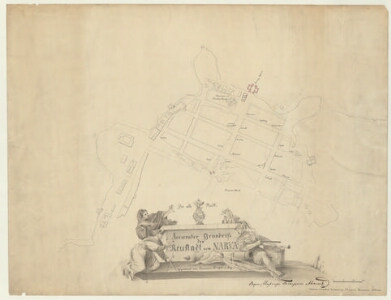
| Title | Accurater Grundriss der Neustadt von Narva |
|---|---|
| Map type | Single sheet map |
| Reference code | EAA.1646.1.3451 sheet 1 |
Notes
Illustreeritud pealkirjaraam.
Creators
| Firstname | Lastname | Occupation of cartographer | Creators position |
|---|---|---|---|
| Francken | author of base map | ||
| Peterson | 1-klassi konduktor | cartographer |
Cartographical and Publishing Description
| Main subject | Not set |
|---|---|
| Material designaton | plan |
| Manuscript/Printed | manuscript copy |
| Base map(s) year | 1741 |
| Created | 1858 |
Components and Mathematical Description
| Components | illustrated, graphical scale |
|---|---|
| Azimuth | Not set |
| Textual scale | 30 [Faden] = 4,8 cm |
| Relative scale | 1300 |
Geographical Description
| Admin unit | Specification |
|---|---|
| Estonia (to 1917) / Estonia Guberniya / Viru County / Narva City/Town (to 1917) | Narva |
Physical Description
| Storage form | streched |
|---|---|
| Material and mounting | paper |
| Medium | ink |
| Dimensions (cm) | 63x49/A1 |
| Access-restrictions | No access restriction |