Detailed description
To view the map area,
sign in or create account
sign in or create account
28.17478 59.35855, 28.20705 59.39163
Identity Description
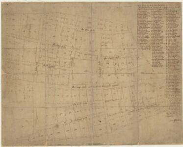
| Title | Grund-Riss von der Stadt Narva Wohn-Plätzen und Strassen, wie die Selbe durch abmessung C. C. Raths in Buifeyn aus dem Bau-Collegie Hinrich Brünings befunden worden A.D. 1684. |
|---|---|
| Map type | Single sheet map |
| Reference code | EAA.1646.1.3436 sheet 1 |
Notes
Kõrval kirjas üle 100 krundi omaniku või haldaja.
Creators
| Firstname | Lastname | Occupation of cartographer | Creators position |
|---|---|---|---|
| Georg | Miller | cartographer |
Cartographical and Publishing Description
| Main subject | Not set |
|---|---|
| Material designaton | plan |
| Manuscript/Printed | manuscript copy |
| Base map(s) year | 1684 ? |
| Created | 18. saj |
Components and Mathematical Description
| Components | explication |
|---|---|
| Azimuth | Not set |
| Textual scale | [puudub] |
| Relative scale | Not set |
Geographical Description
| Admin unit | Specification |
|---|---|
| Estonia (to 1917) / Estonia Guberniya / Viru County / Narva City/Town (to 1917) | Narva |
Physical Description
| Storage form | streched |
|---|---|
| Material and mounting | paper |
| Medium | ink+coloured |
| Dimensions (cm) | 54x42/A2 |
| Access-restrictions | No access restriction |