Detailed description
To view the map area,
sign in or create account
sign in or create account
24.66 58.34, 24.95 58.46
Identity Description
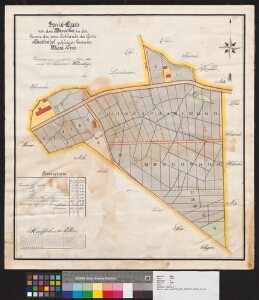
| Title | General-Charte von den Parcellen in der Grenze des zum Hofslande des Gutes Staelenhof gehörigen Gesindes. Wiera. nr. XXIII. |
|---|---|
| Map type | Single sheet map |
| Reference code | EAA.3724.5.1907 sheet 1 |
Creators
| Firstname | Lastname | Occupation of cartographer | Creators position |
|---|---|---|---|
| Th. | Thomberg | maamõõtja | cartographer |
Cartographical and Publishing Description
| Main subject | Not set |
|---|---|
| Material designaton | plan |
| Manuscript/Printed | manuscript original |
| Created | 1900 |
Components and Mathematical Description
| Components | explication, compass |
|---|---|
| Azimuth | Not set |
| Textual scale | 300 küünart on 13,9 cm |
| Relative scale | Not set |
Geographical Description
| Admin unit | Specification |
|---|---|
| Estonia (to 1917) / Livonia Guberniya / Pärnu County / Tori Parish / Taali Manor | Viira nr. XXIII |
Physical Description
| Storage form | Not set |
|---|---|
| Material and mounting | paper+textile |
| Medium | ink+coloured |
| Dimensions (cm) | 59x56/A1 |
| Access-restrictions | No access restriction |