Detailed description
To view the map area,
sign in or create account
sign in or create account
21.81 57.51, 28.25 59.63
Identity Description
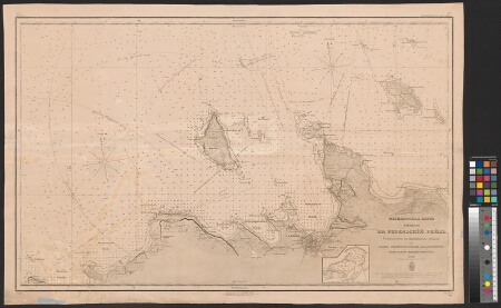
| Title | Меркаторская карта входов на Ревельский рейд. |
|---|---|
| Map type | Single sheet map |
| Reference code | EAA.46.2.337 sheet 1 |
Cartographical and Publishing Description
| Main subject | hydrographic |
|---|---|
| Material designaton | map |
| Manuscript/Printed | printed |
| Base map(s) year | 1846, 1881 |
| Created | 1888 |
Components and Mathematical Description
| Components | grid lines, compass |
|---|---|
| Azimuth | Not set |
| Textual scale | [1:135 000] |
| Relative scale | Not set |
Geographical Description
| Admin unit | Specification |
|---|---|
| Estonia (to 1917) |
Physical Description
| Storage form | streched |
|---|---|
| Material and mounting | paper |
| Medium | printed |
| Dimensions (cm) | 99x64/A0 |
| Access-restrictions | No access restriction |