Detailed description
To view the map area,
sign in or create account
sign in or create account
25.71 41.47347, 28.41 82.06518
Identity Description
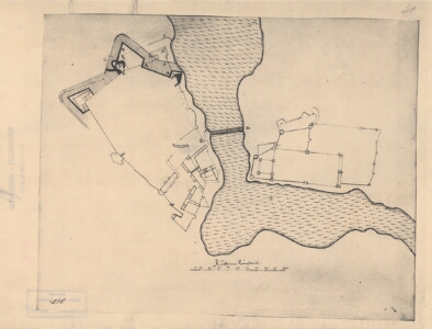
| Title | [Narva ja Ivangorodi kindluste plaan] |
|---|---|
| Map type | Single sheet map |
| Reference code | EAA.1646.1.2637 sheet 31 |
Cartographical and Publishing Description
| Main subject | Not set |
|---|---|
| Material designaton | plan |
| Manuscript/Printed | manuscript copy |
| Created | 1934 |
Components and Mathematical Description
| Components | graphical scale |
|---|---|
| Azimuth | Not set |
| Textual scale | 100 reini ruutu on 8,3 cm |
| Relative scale | 6600 |
Geographical Description
| Admin unit | Specification |
|---|---|
| Estonia (1917-1950) / Viru County | Ivangorod, Narva |
| other / Europe Continent / Eastern Europe Region / Russia | Ivangorod, Narva |
Physical Description
| Storage form | streched |
|---|---|
| Material and mounting | paper |
| Medium | photo |
| Dimensions (cm) | 39x30/A2 |
| Access-restrictions | No access restriction |