Detailed description
To view the map area,
sign in or create account
sign in or create account
21.81 57.51, 27.70 59.05
Identity Description
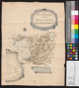
| Title | Post-Charte von dem Lieflaendischen Gouvernement. |
|---|---|
| Map type | Multiple-sheet map |
| Reference code | EAA.3724.5.1580 sheet 1 |
Subsheets
| Reference code |
|---|
| EAA.3724.5.1580 sheet 4 |
| EAA.3724.5.1580 sheet 6 |
Cartographical and Publishing Description
| Main subject | other |
|---|---|
| Material designaton | plan |
| Manuscript/Printed | manuscript original |
| Created | 1800 (Estimated) |
Components and Mathematical Description
| Components | legend for symbols, compass, graphical scale |
|---|---|
| Azimuth | Not set |
| Textual scale | Maasstab von 120 Werst oder 18 Meilen = 7,7 cm |
| Relative scale | 1660000 |
Geographical Description
| Admin unit | Specification |
|---|---|
| Estonia (to 1917) / Livonia Guberniya |
Physical Description
| Storage form | rolled |
|---|---|
| Material and mounting | paper |
| Medium | ink+coloured |
| Dimensions (cm) | 41x30/A2 |
| Access-restrictions | No access restriction |