Detailed description
To view the map area,
sign in or create account
sign in or create account
23.70 58.27, 24.09 58.50
Identity Description
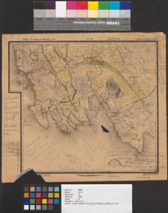
| Title | Eesti- ja Liivimaa kubermangud. 14-24 Lääne ja Pärnu maakonnad. Эстляндская и Лифляндская губерния. 14-24 Гапсальский и Перновский уезд |
|---|---|
| Map type | Single sheet map |
| Reference code | ERA.T-6.3.861 sheet 2 |
Notes
Topograafiline
Cartographical and Publishing Description
| Main subject | administrative |
|---|---|
| Material designaton | map |
| Manuscript/Printed | printed |
| Published by | S. Kartograafia trükk |
| Created | 1905 |
Components and Mathematical Description
| Components | grid lines, graphical scale |
|---|---|
| Azimuth | Not set |
| Relative scale | 42000 |
Geographical Description
| Admin unit | Specification |
|---|---|
| Estonia (to 1917) / Estonia Guberniya / Lääne County / Varbla Parish / Saulepi Commune (1866-1917) | |
| Estonia (to 1917) / Livonia Guberniya / Pärnu County / Tõstamaa Parish / Tõstamaa Commune (1866-1917) |
Physical Description
| Storage form | streched |
|---|---|
| Material and mounting | paper |
| Medium | printed |
| Dimensions (cm) | 32x34/A2 |
| Access-restrictions | No access restriction |
Maps referring to this map
| Reference code | Manuscript/Printed |
|---|---|
| ERA.T-6.3.861 sheet 1 | printed |