Detailed description
To view the map area,
sign in or create account
sign in or create account
25.44 57.98871, 25.62 58.13
Identity Description
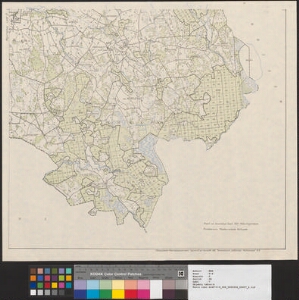
| Title | Eesti NSV Abja rajooni põllumajanduslik kaart |
|---|---|
| Map type | Single sheet map |
| Reference code | ERA.T-6.5.36 sheet 7 |
Cartographical and Publishing Description
| Main subject | administrative |
|---|---|
| Material designaton | index map; outline map |
| Manuscript/Printed | printed |
| Published by | 29. XI. 1957, Saraatov |
| Created | 1957 |
Components and Mathematical Description
| Components | explication, legend for symbols, graphical scale |
|---|---|
| Azimuth | Not set |
| Relative scale | 50000 |
Geographical Description
| Admin unit | Specification |
|---|---|
| Estonia (1950-1991) / Abja County (1950-1963) / Lilli (until 1954 Äri) Village Council (1945-1960) | |
| Estonia (1950-1991) / Abja County (1950-1963) / Polli Village Council (1945-1963) |
Physical Description
| Storage form | streched |
|---|---|
| Material and mounting | paper |
| Medium | printed |
| Dimensions (cm) | 50x58/A1 |
| Access-restrictions | No access restriction |
Maps referring to this map
| Reference code | Manuscript/Printed |
|---|---|
| ERA.T-6.5.36 sheet 1 | printed |