Detailed description
To view the map area,
sign in or create account
sign in or create account
27.15 57.82, 27.31 57.93
Identity Description
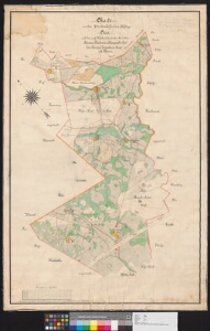
| Title | Charte von der Beutenhofschen Hoflage Otsa und den auf Hofsland fundierten Gesinden Mäesaare, Rästasaare, Kängopallo, Kullase, Törwapa, Leppistlane, Sirgo und Kanno. |
|---|---|
| Map type | Single sheet map |
| Reference code | EAA.3724.4.1912 sheet 1 |
Creators
| Firstname | Lastname | Occupation of cartographer | Creators position |
|---|---|---|---|
| Carl | Blossfeldt | Liivimaa rüütelkonna maamõõtja | cartographer |
Cartographical and Publishing Description
| Main subject | Not set |
|---|---|
| Material designaton | plan |
| Manuscript/Printed | manuscript original |
| Created | 1887 |
Components and Mathematical Description
| Components | compass |
|---|---|
| Azimuth | Not set |
| Textual scale | 1300 küünart |
| Relative scale | Not set |
Geographical Description
| Admin unit | Specification |
|---|---|
| Estonia (to 1917) / Livonia Guberniya / Võru County / Rõuge Parish / Pindi Manor | Mäesaare, Rästasaare, Kängopallo, Kullase jne. |
Physical Description
| Storage form | Not set |
|---|---|
| Material and mounting | paper+textile |
| Medium | ink+coloured |
| Dimensions (cm) | 100x67/A0 |
| Access-restrictions | No access restriction |