Detailed description
To view the map area,
sign in or create account
sign in or create account
26.84 57.99, 27.04 58.15
Identity Description
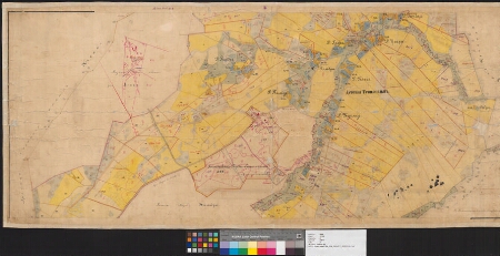
| Title | План крест. земелъ казеннаго имения Геймадра, Лифл. губ. Верроскаго уезда. |
|---|---|
| Map type | Subsheet |
| Reference code | EAA.3724.4.1877 sheet 3 folio 2 |
Belongs to main sheet
EAA.3724.4.1877 sheet 8 folio 1
Creators
| Firstname | Lastname | Occupation of cartographer | Creators position |
|---|---|---|---|
| A. | Telitsõn | cartographer |
Cartographical and Publishing Description
| Main subject | Not set |
|---|---|
| Material designaton | plan |
| Manuscript/Printed | manuscript original |
| Created | 1875 |
Components and Mathematical Description
| Components | legend for symbols, compass, graphical scale |
|---|---|
| Azimuth | Not set |
| Textual scale | 1 toll = 50 sülda |
| Relative scale | 4200 |
Geographical Description
| Admin unit | Specification |
|---|---|
| Estonia (to 1917) / Livonia Guberniya / Võru County / Põlva Parish / Kähri Manor |
Physical Description
| Storage form | rolled |
|---|---|
| Material and mounting | paper |
| Medium | ink+coloured |
| Dimensions (cm) | 121x64/2A0 |
| Access-restrictions | No access restriction |