Detailed description
To view the map area,
sign in or create account
sign in or create account
26.44 57.63, 26.68 57.86
Identity Description
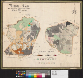
| Title | Bestands-Charte von dem Alt-Anzenschen Walde. Revier Kruusa. |
|---|---|
| Map type | Single sheet map |
| Reference code | EAA.3724.4.1846 sheet 1 |
Cartographical and Publishing Description
| Main subject | Not set |
|---|---|
| Material designaton | plan |
| Manuscript/Printed | Not set |
| Created | 1911 |
Components and Mathematical Description
| Components | legend for symbols, compass |
|---|---|
| Azimuth | Not set |
| Textual scale | 1300 küünart |
| Relative scale | Not set |
Geographical Description
| Admin unit | Specification |
|---|---|
| Estonia (to 1917) / Livonia Guberniya / Võru County / Urvaste Parish / Vana Antsla Manor |
Physical Description
| Storage form | Not set |
|---|---|
| Material and mounting | paper+textile |
| Medium | ink+coloured |
| Dimensions (cm) | 68x57/A1 |
| Access-restrictions | No access restriction |